Volume 3

place matters is an e-newsletter that shares news, perspectives, and progress from CDC/ATSDR’s Geospatial Research, Analysis, and Services Program (GRASP).
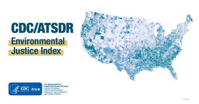
GRASP launched the new Environmental Justice Index (EJI) on August 10th. The EJI is the first national, place-based tool designed to measure the cumulative impacts of environmental burden through the lens of human health and health equity.
This new tool delivers a single score for each community so that public health officials can identify and map areas most at risk for the health impacts of environmental burden.
The EJI is the result of several collaborations across the agency and the U.S. Department of Health and Human Services (HHS). The GRASP team thanks NCEH’s National Environmental Public Health Tracking Program, the NCEH Office of Priority Projects, Innovation, and Environmental Justice, NCCDPHP’s Division of Population Health, and the HHS Office of Environmental Justice.
View the EJI tool online, including access to FAQs, data documentation, and additional information on the EJI website.
UPCOMING EJI WEBINARS
You’re invited to attend upcoming webinars that will showcase The Environmental Justice Index: a National Tool to Measure the Cumulative Impacts of Environmental Burden on Health.
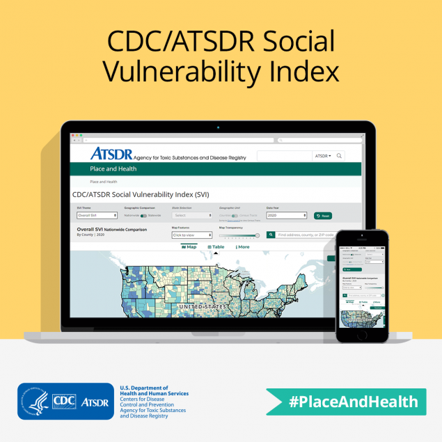
The CDC/ATSDR Social Vulnerability Index (CDC/ATSDR SVI) has a new interactive map and a new, updated dataset.
The CDC/ATSDR SVI was first launched by ATSDR’s Geospatial Research, Analysis, and Services Program (GRASP) in 2011. To mark the second decade of the tool, GRASP has released a new interactive map using a Census 2020 dataset.
The CDC/ATSDR SVI uses data from the U.S. Census Bureau to score each community’s (census tract level) social vulnerability. These scores are used by public health officials and emergency response planners to identify communities that may need additional support before, during, or after disasters or disease outbreaks.
Collaboration is the backbone of environmental justice work — and the Geospatial Research, Analysis, and Services Program (GRASP) is here to help. GRASP works with federal, state, and local health organizations, academic institutions, and non-governmental organizations to advance environmental justice.
Check out this short video to learn how GRASP can help your organization create a cleaner, healthier, and more equitable future for everyone.

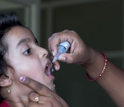
Globally, 20 million children have received incomplete or no life-saving vaccines. Nearly half of them live in countries where conflicts and population displacement make it difficult to reach children with essential vaccinations. When health professionals miss even a single child during polio vaccine campaigns, it can negatively impact global polio eradication efforts.
GIS experts and staff from CDC’s Center for Global Health (CGH); CDC/ATSDR’s Geospatial Research, Analysis, and Services Program (GRASP); the World Health Organization (WHO); and Maxar Technologies Inc. collaborated to enhance existing polio campaign efforts by using geographic information systems (GIS) and satellite imagery.
Through this collaboration, a mapathon (community mapping activity) and innovative machine learning technologies were effective tools to improve remote location surveillance and inform logistics and delivery strategies needed to reach children in Central Asia.
Learn more about using GIS and satellite imagery to support public health work.
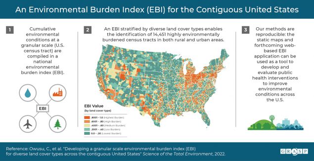
A team of GRASP staff members developed an environmental burden index (EBI) to help identify the cumulative impacts of environmental conditions across the United States. The EBI was developed over the course of four stages:
- Literature review to identify potential indicators
- Data source acquisition and indicator variable construction
- Index creation
- Stratification by land cover type
For each potential indicator, data sources were assessed for completeness, update frequency, and availability. Indicators included measures like particulate matter (PM2.5), ozone, Superfund National Priorities List (NPL) locations, railways, recreational parks, highways, airports, and impaired water sources, to name a few.
The EBI is calculated at the U.S. census tract level, which is a finer scale than other similar tools. It is also stratified by land cover to control for urbanicity. The EBI has many potential applications for research and use as a tool to develop public health interventions at a granular scale.
For more information:
Owusu C*, Flanagan B*, Lavery AM*, Mertzlufft CE*, McKenzie BA*, Kolling J*, Lewis B*, Dunn I*, Hallisey E*, Lehnert EA*, Fletcher K*, Davis RT*, Conn M*, Owen LR*, Smith MM*, Dent A*. Developing a granular scale environmental burden index (EBI) for diverse land cover types across the contiguous United States. Science of The Total Environment. Volume 838, Part 1, 2022, 155908.
*Indicates GRASP author
Donovan C, Worrell MC, Steinberg J, Montgomery BK, Young R*, Richardson G*, Dawson P, Dinh TH, Botkin N, Fitzpatrick T, Fields A, Rains CM, Fritz S, Malone S, Tong S, Mooney J, Newland JG, Barrios LC, Neatherlin JC, Salzer JS, Missouri School Measurement Team. An Examination of SARS-CoV-2 Transmission Based on Classroom Distancing in Schools With Other Preventive Measures in Place—Missouri, January–March 2021. Public Health Reports. 2022;137(5):972-979. Date published: July 16, 2022
Mendes A*, Whiteman A*, Bullard K, Sharif S, Khurshid A, Alam AA, Salman M, Ford V, Blair T, Burns CC, Ehrhardt D, Jorba J, Hsu CH. Spatial analysis of genetic clusters and epidemiologic factors related to wild poliovirus type 1 persistence in Afghanistan and Pakistan. PLOS Global Public Health 2(6): e0000251. Date Published: June 13, 2022
Owusu C*, Flanagan B*, Lavery AM*, Mertzlufft CE*, McKenzie BA*, Kolling J*, Lewis B*, Dunn I*, Hallisey E*, Lehnert EA*, Fletcher K*, Davis RT*, Conn M*, Owen LR*, Smith MM*, Dent A*. Developing a granular scale environmental burden index (EBI) for diverse land cover types across the contiguous United States. Science of The Total Environment. Volume 838, Part 1, 2022, 155908. Date Published: May 16, 2022
Wiesen E, Dankoli R, Musa M, Higgins J*, Forbi J, Idris J, Waziri N, Ogunbodede O, Mohammed K, Bolu O, WaNgandaG, Adamu U, Pinsker E. Conducting public health surveillance in areas of armed conflict and restricted population access: a qualitative case study of polio surveillance in conflict-affected areas of Borno State, Nigeria. Confl Health 16, 20 (2022). Date published: May 7, 2022
McKenzie B*, Espey J*, Garber M*, Taliano J, Dent A*, Foster S*, Kaplan P*, McCain K*, Owen LR*, Owusu C*, Richardson G*, and Curriero F*. The Geospatial Determinants of Health: A Protocol for Conducting a Scoping Review of Theoretical Frameworks. osf.io/x8z6f. Date Published February 23, 2022
Ramesh B, Jagger MA, Zaitchik B, Kolivras KN, Swarup S, Deanes L, Hallisey E, Sharpe JD*, Gohlke JM. Flooding and emergency department visits: Effect modification by the CDC/ATSDR Social Vulnerability Index. International Journal of Disaster Risk Reduction. 2022; Volume 76, 102986. Date published: April 28, 2022
Van Dyke ME, Chen MS, Sheppard M, Sharpe JD*, Radhakrishnan L, Dahlberg LL, Simon TR, Zwald ML. County-Level Social Vulnerability and Emergency Department Visits for Firearm Injuries — 10 U.S. Jurisdictions, January 1, 2018-December 31, 2020. MMWR Morb Mortal Wkly Rep 2022;71:873–877. Date published July 8, 2022
Wolkin A, Collier S, House JS, Reif D, Motsinger-Reif A, Duca L, Sharpe JD*. Comparison of National Vulnerability Indices Used by the Centers for Disease Control and Prevention for the COVID-19 Response. Public Health Reports. 2022;137(4):803-812. Date published May 5,2022
*Indicates GRASP author
In each newsletter, we share a short profile of key GRASP team members. In today’s volume, meet Ben McKenzie.

Ben McKenzie, MS – Environmental Justice Index, project coordinator
Ben McKenzie is a geospatial epidemiologist and project coordinator with ATSDR’s Geospatial Research, Analysis, and Services Program (GRASP) with a portfolio focusing on environmental health, environmental justice, and health equity.
Since 2021, Ben has served as the team lead for the Environmental Justice Index project in collaboration with the National Environmental Public Health Tracking Program, the National Center for Environmental Health Office of Priority Projects, Innovation and Environmental Justice, and the U.S. Department of Health and Human Services Office of Environmental Justice.
Ben has a master’s in Wildlife Sciences from Auburn University and a Bachelor of Science in Ecology and Evolutionary Biology from Sewanee: The University of the South.
Ben lives in Atlanta with his wife and one goofy, but loveable dog named Zelda.
Ben’s Favorites
Food – New recipes I get to try out at home!
Hobby – Solving crosswords.
Vacation – Anywhere with a good mix of history, nature, and good food. Mountains, ocean, botanical gardens, and museums are a plus.
Book(s) – Really hard to pick, but probably a three-way tie between Anna Karenina, The Lord of the Rings trilogy, and Mountains Beyond Mountains.
Sign up to have place matters delivered to your mailbox:
Thank you for your interest in place matters. We want to hear from you. Your feedback is important to us. Let us know what you liked and what you’d like us to change, and your ideas for future newsletters. Send us an email at placeandhealth@cdc.gov.
We encourage you to share the newsletter with your networks. If you’ve received this newsletter from a colleague, please subscribe so we can send the next issue of place matters directly to your inbox.
Interested in learning more about GRASP? Email us at placeandhealth@cdc.gov.