Volume 1

place matters is an e-newsletter that shares news, perspectives, and progress from CDC/ATSDR’s Geospatial Research, Analysis, and Services Program (GRASP).
Welcome to the first edition of place matters, the newsletter of the Geospatial Research, Analysis, and Services Program (GRASP). Our mission is to provide leadership, expertise, and education in the application of geography, geospatial science, and geographic information systems (GIS) to public health research and practice.
In this newsletter, we look forward to bringing you success stories, new publications, best practices, and news from the geospatial community. In this first edition, we share highlights from our new Place & Health website and our work supporting the COVID-19 response.
We want to hear from you. We invite you to suggest topics for future newsletters such as progress in the field of geospatial epidemiology, GIS tips, and your project highlights. Send your suggestions to placeandhealth@cdc.gov.
We value your interest in GRASP, and we look forward to keeping you informed.
Take care,

Andy Dent, MS, MBA, GRASP Program Director

GRASP is a team of geospatial science, technology, visualization, analysis, and public health experts within the Agency for Toxic Substances and Disease Registry (ATSDR) and CDC.
In 1989, the program that would eventually become GRASP was established to examine environmental exposure at hazardous waste sites. GRASP supports ATSDR by using geospatial science, technology, and visualization for site-specific exposure investigations and helps the public better understand complex environmental exposures.
GRASP champions CDC/ATSDR’s efforts to examine the intersection of place and health, and how that relationship impacts the public’s health. Learn more about the mission and objectives of GRASP on our Getting to Know GRASP web page.
We launched our new website, Place and Health in 2020. Place and Health illustrates the important connection between place and health, and shares information about the work of GRASP. The new website showcases a large portfolio of collaborative projects spanning public health research and practice, including environmental health, infectious and chronic disease, injury, and public health emergency preparedness, response, and recovery.
Our goal is to share the connection between place and health, highlight projects, and increase awareness of the important role GRASP plays in supporting CDC’s public health work and ATSDR’s mission to protect communities from harmful health effects related to exposure to natural and man-made hazards.


GRASP has played a long-standing role in providing geospatial support to public health partners. We have put together a timeline of key milestones in GIS and geospatial science at CDC/ATSDR over the years. Learn more about some of these key milestones in our Place & Health timeline.
GRASP geospatial scientists, GIS analysts, technologists, and epidemiologists continue to collaborate with the Emergency Operations Center and across CDC/ATSDR to support the COVID-19 response. Below are highlights of key GIS, spatial analysis, cartographic, and web application development projects for the response.
CDC COVID Data Tracker
Since its release in April 2020, millions have visited the COVID Data Tracker for essential and timely data on COVID-19. As pages are continuously updated, visitors can access data and visualizations of patterns and trends in cases, laboratory testing, emergency department visits, social impacts of the disease (such as school closures), U.S. vaccine distribution data, and more.
COVID-NET
COVID-NET is CDC’s system that collects data on laboratory-confirmed COVID-19 hospitalizations in 250 acute-care hospitals in 14 states. COVID-NET also provides important clinical information on people with COVID-19-associated hospitalizations, including age group, sex, race/ethnicity, and underlying health conditions.
GRASP released updates to phases 3 and 5 of COVID-NET last fall. Phase 3 now includes data on race/ethnicity and sex of people with COVID-19 related hospitalizations, in addition to age group stratification. The updated interface enables users to clearly visualize data, with the added ability to create and download charts. These new features will be applied to the next phase of the FluView Interactive web application. In Phase 5, hospitalization characteristics now include data on pediatric age groups.
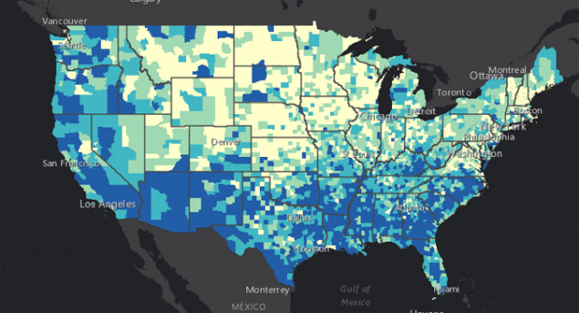
The CDC Social Vulnerability Index (SVI) is a database that helps CDC scientists, emergency preparedness and response organizations, and public health officials identify, map, and plan support for communities that are most likely to need assistance before, during, and after a public health emergency. The SVI identifies communities facing public health challenges—such as environmental exposure and lack of access to healthcare—and helps decision makers allocate resources. GRASP created the first version of the SVI in 2011 to enable the public health community to quickly identify socially vulnerable populations and plan assistance for them over the entire course of hazardous events. We will bring you key updates on SVI in upcoming newsletters, as well as additional resources related to social vulnerability in the geospatial community, including the following:
- GRASP released the official CDC SVI 2018 update in March 2020. Access the newest update on the CDC SVI Data & Documentation Download page.
- GRASP led the June 2020 publication of Spatial exploration of the CDC’s Social Vulnerability Index and heat-related health outcomes in Georgia in the International Journal of Disaster Risk Reduction.

GRASP team members apply their knowledge in geography, geospatial science, and geographic information systems (GIS) as first and contributing authors in a variety of publications.
Featured Publication
Ekperi LI, Thomas E, LeBlanc TT, Adams EE*, Wilt GE*, Molinari N, Carbone EG. The Impact of Hurricane Sandy on HIV Testing Rates: An Interrupted Time Series Analysis, January 1, 2011‒December 31, 2013. PLOS Currents Disasters. 2018 Sep 13. Edition 1.
2020 Publications
Kalkowska DA, Franka R, Higgins J*, Kovacs SD, Forbi JC, Wassilak SGF, Pallansch MA, Thompson KM. Modeling Poliovirus Transmission in Borno and Yobe, Northeast Nigeria. Risk Analysis. 20 April 2020.
Nakiire L, Mwanja H, Pillai SK, Gasanani J, Ntungire D, Nsabiyumva S, Mafigiri R, Muneza N, Ward SE, Daffe Z, Ahabwe PB, Kyazze S, Ojwang J, Homsy J, McIntyre E,* Lamorde M, Walwema R, Makumbi I, Muruta A, Merrill RD. Population Movement Patterns Among the Democratic Republic of the Congo, Rwanda, and Uganda During an Outbreak of Ebola Virus Disease: Results from Community Engagement in Two Districts — Uganda, March 2019. MMWR Morb Mortal Wkly Rep. 2020;69(1):10.
Stephens W, Wilt GE,* Lehnert EA,* Molinari NM, LeBlanc TT. A Spatial and Temporal Investigation of Medical Surge in Dallas-Fort Worth During Hurricane Harvey, Texas 2017. Disaster Med Public Health Prep. 14(1), 111-118.
*Indicates GRASP author
Sign up to have place matters delivered to your mailbox:
Thank you for your interest in place matters. We want to hear from you. Your feedback is important to us. Let us know what you liked and what you’d like us to change, and your ideas for future newsletters. Send us an email at placeandhealth@cdc.gov.
We encourage you to share the newsletter with your networks. If you’ve received this newsletter from a colleague, please subscribe so we can send the next issue of place matters directly to your inbox.
Interested in learning more about GRASP? Email us at placeandhealth@cdc.gov.